Corona Sites Listed on the State and National Register of Historic Places
WOMAN’S IMPROVEMENT CLUB CLUBHOUSE
CORONA
HIGH
SCHOOL
GRAND BOULEVARD HISTORIC DISTRICT
CORONA
THEATER
THOMAS
JEFFERSON
ELEMENTARY
SCHOOL
Andrew Carnegie Library 1906-1978
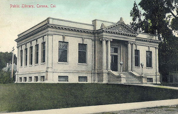
Early postcard view from the northwest, before the addition of any landscaping
Carnegie, Andrew, Library (added 1977 - Building - #77000324)
Also known as Old Corona Public Library
Location: Eighth and Main Streets., (805 Main Street, Corona
Historic Significance: Event, Architecture/Engineering
Architect, builder, or engineer: Bloom, S.L., Burnham, Franklin Pierce
Architectural Style: Classical Revival
Area of Significance: Architecture, Social History
Period of Significance: 1900-1924
Owner: Local Gov't (until demolition in 1978)
Historic Function: Education Historic Sub-function: Library
1977 Function: Vacant/Not In Use
Current Function: Demolished in 1978 and replaced with a medical office
Building in 2016
This iconic Classic Revival style structure was built in 1906 with a $10,000. grant and
$1,500. supplement from the Andrew Carnegie Foundation and some $500. in locally
raised funds. It served as Corona’s public library until 1971. The dark wood interior trim
contrasted with its cream colored walls and pillars. There were large fireplaces in each
main floor room and a large dome-like central skylight ensured diffused lighting for day
time patrons. Sadly, rather than repurposing this treasured building, it was abruptly demolished
in 1978 to make way for a Pioneer Chicken franchise, which was never built. A
medical office building, named Carnegie Medical Plaza, now occupies the site.
Corona Woman’s Improvement Club Clubhouse 1913-present
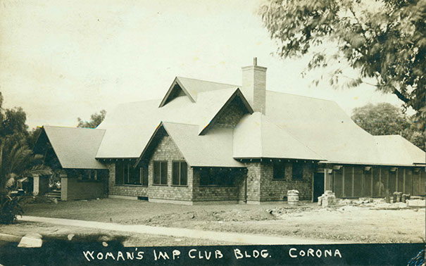
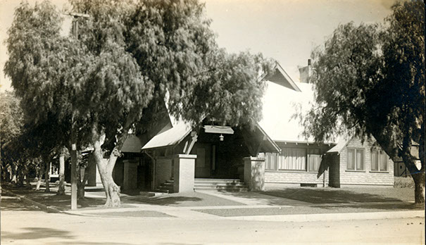
Views while under construction
Woman's Improvement Club Clubhouse (added 1988 -Building - #88002014)
Location: 1101 S. Main St., Corona
Historic Significance: Event, Architecture/Engineering
Architect, builder, or engineer: Preston, Thomas E.
Architectural Style: Bungalow/Craftsman
Area of Significance: Architecture, Social History
Period of Significance: 1900-1924, 1925-1949
Owner: Private
Historic Function: Social Historic Sub-function: Clubhouse
Current Function: Social Current Sub-function: Clubhouse
The Woman’s Improvement Club Clubhouse sits on the southeast corner of Main Street at Eleventh Street. It was built in 1913, in the Craftsman architectural style, with some additional period revival modifications, by Los Angeles architect Thomas E. Preston, based on details from an anonymous Welsh church. The building has been in continuous use by a service organization since its construction.
Although the structure was copied after a church, the building appears more like a residence with an old-fashioned porch welcoming visitors to the front door on the Main Street side. Main Street side. The corner porch has a plain wooden bench and an original metal craftsmen light fixture. A wooden flagpole extends from the tie beam above the porch roof and is reminiscent of wooden crosses placed at gable ridges on Old English churches. The clubhouse is a detached one-story woodframed structure which is nearly T-shaped. Dark brown painted wood shingles sheath the exterior walls above a beige brick foundation. The chimney and porch piers are of matching brick.
Covered by white lace curtains and trimmed with narrow wooden molding, several types of windows are found in the clubhouse. The large ribbon windows in the parlor illuminate a gracious room with period furniture and an attractive brick fireplace. On the wall above the mantel are two carved oak panels; they are florals and not identical to each other. These panels are original and were created by a local doctor who offered them as a gift on “Cornerstone Day.” Several original interior doors and hardware are still in place.
Beyond the parlor is a large meeting room with a small stage that has seen hundreds of programs and performances. The trough for footlights on the stage has now been removed, but the fervor of past productions remains the same. Rooms to each side of the stage allow nervous performers to rehearse their lines and change into costumes. In the meeting room, the vaulted ceiling has exposed wooden beams with steel connectors and rods. Four sets of double doors with two-over-two glass in the top halves separate the south side of the meeting hall from the enclosed sun porch. At the west end of the meeting hall, five very large wood-paneled doors fold open or slide closed to divide the hall from the parlor.
The small south wing on the west wall houses the kitchen with its modern appliances, and has casement and double-hung windows. Camellias and roses from the outside landscaping are sometimes used to beautify the already attractive interior. t. A bronze marker memorializing the structure’s listing on the National Register of Historic Places in 1988, is found on the right front porch post.
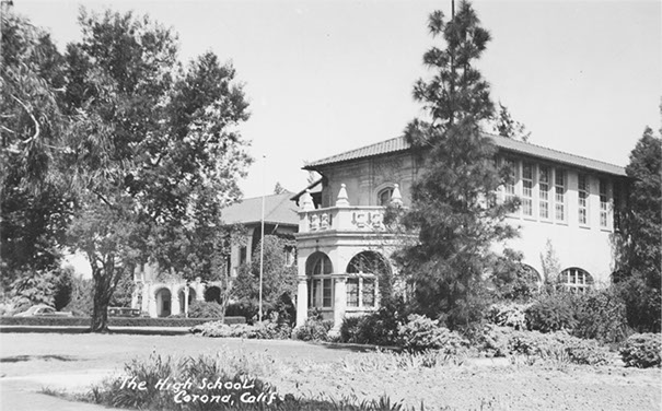
Early view of Corona Senior High School with the south end of the library wing in the foreground
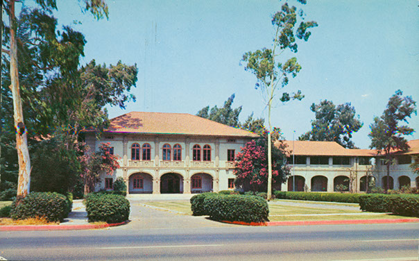
Front view of Corona Senior High School after the addition of the central U-shaped driveway
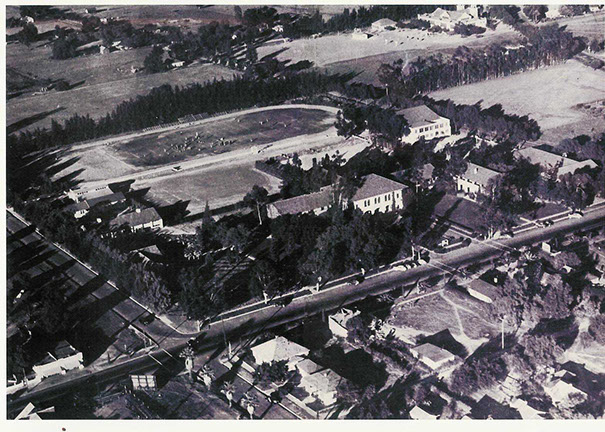
1941 Aerial view of the campus from the southeast Buend Vista Street and Sixth Street intersection in left foreground
Corona High School (added 2005 - Building - #05000772)
Also known as Corona High School # 2 / Corona Historic Civic Center
Location: 815 W. Sixth St., Corona
Historic Significance: Event, Architecture/Engineering
Architect, builder, or engineer: Sias, Richard, Wilson, G. Stanley
Architectural Style: Mission/Spanish Revival
Area of Significance: Social History, Architecture
Period of Significance: 1900-1924, 1925-1949, 1950-1974
Owner: Local Government
Historic Function: Education Historic Sub-function: School
Current Function: Government Current Sub-function: City Hall/Civic Center
The main building is set behind a beautifully landscaped lawn with a central fountain,that re placed a U-shaped driveway constructed in 1926, from the street to the entry portico. This two-story structure is built in Mediterranean – Spanish Revival style achitecture, with various rectangular sections. There is a large sunburst window above the front doors beneath the portico’s arches.
The auditorium at the center-rear of the building is characterized by the use of massive wood trusses to support the roof resting on reinforced pilasts. Classroom wings with covered breezeways extend to the east and west of the auditorium.
The structure immediately to the east and south of the east wing of the main structure, was constructed in 1931 of reinforced concrete and was used for classrooms/library. A half-round second floor balcony on the south end above the library’s ever present round “study hall” table and reading area. The balcony was accessed by a flattened arch doorway. Above the doorway is found a marvelous coat of arms characterized by an oval shield on the scroll edged escutcheon with the lamp of learning and an open book depicted. To each side of the escutcheon is found a student, a girl on the left, a boy on the right, each with an open book in his/her hands. This structure served as the City Manager’s office for many years. The structure farther east was used for the school cafeteria, food preparation areas and the Domestic Science (home economics) Department. North of the home economics structure is the school gymnasium which has complementary architectural elements remains in use at the present time with City Parks and Community Services recreation athletic activities.
Construction on the main building began in 1923 and it opened for students September 11, 1923. The three arches over the recessed entry portico are embellished with columns, cornices and various moldings. Fourteen (14) ornate low relief carvings/ castings appear below the second floor balconet railings above the entrance, and also on the side windows. Three themes (learning, natural sciences and fine arts) are repeated in these scroll edged escutcheon castings. A symmetrical shield with point at the bottom, a flaming torch at the top and a scroll and open book represent learning The natural sciences are depicted on an irregular shaped shield and represented by a globe, various engineering or astronomical measuring instruments and the sun, moon and stars. Fine Arts are represented on an oval shield by an artist’s palette and brushes, the capital (top) of an ionic column representing architecture and a partially rolled fabric or paper scroll on which drawings or paintings may be made. Six of these castings symmetrically highlight double arched second story windows corresponding to the open arches at the recessed front entry. Two escutcheons are located on the second story single window balconets to the left and right of the entry. Three escutcheons are located on the balconets of the triple windows located on the sides of the main entry façade. Under the eaves, characterized by sculpted rafter tails, are large oval vents with decorative vertical spindles. The central hip roof is covered with clay tile, the east and west end sections of the roof are gabled and are also covered with clay tile.
Grand Boulevard Historic District 1886-present
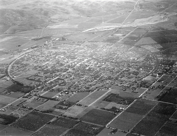
1918 aerial Image of circular roadway
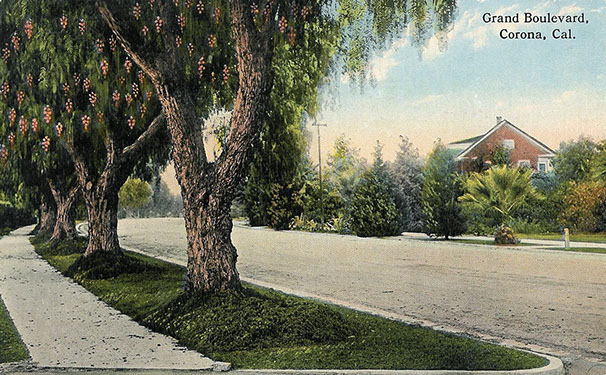
Early 20th Century postcard depicting the curve of this circular roadway
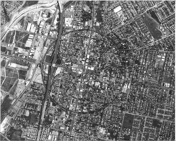
Grand Boulevard Streetscape (Added 2011 – Historic District - #11000432)
Also known as “The Boulevard” or “The Circle”
Location: A circular roadway 3 miles in circumference whose center Is located
on Sixth Street, approximately 300 feet east of Main Street, Corona
Historic Significance:. The circular roadway gave rise to the city’s nickname
“The Circle City” and is the only Boulevard in town.
Architect, builder, or engineer: Hiram Clay Kellogg, Civil Engineer
Area of Significance: Community Planning & Development,
Entertainment - Recreation, Politics & Government
Period of Significance: 1886 – present
Significant dates: 1913, 1914 & 1916 internationally recognized road races
Owner: Local Government
Historic Function: Transportation related – vehicular
Recreation & Culture, sports facility - Speedway
Historic sub-function: Automobile racecourse 1913, 1914, 1916
Current Function: Government, Public Works, Roadway.
The Historic District is within the existing right-of-way for Grand Boulevard and is one of the city’s original streets set out within the map of Lands of South Riverside Land & Water Company, recorded on February 12, 1887, in the records of San Bernardino County; prior to the establishment of Riverside County..
The map was surveyed and drawn in 1886 by Hiram Clay Kellogg, an Anaheim engineer of note. Anecdotally it is recorded that he also laid out the roadway in three days after a competing engineer indicated that it could not be completed in several weeks.
The roadway and original improvements were established in 1887 with the original circular configuration remaining intact to this day. The planting within the wide parkways contain many large mature trees, planted during the early part of the 1900s.
The unique circular roadway was a prominent design feature used as an automobile race course for internationally acclaimed road races in 1913, 1914 and 1916 to attract prospective citizens, businessmen and investors. For the 1913 race some 100,000 spectators were drawn to Corona. Racing legends competed here as well. One of the palm trees planted in the nineteenth century still bears the marks from a collision with one of the legendary racecars.
Grand Boulevard is a unique circular roadway, one-mile in diameter and nearly three miles in circumference, which has given rise to the longstanding moniker “The Circle City”, which makes Corona distinctive from any other city. The city’s only “Boulevard”, it contains wide parkways, large mature trees, and historic street lamps fronting the stately homes of the city founders and early city leaders.
The Boulevard continues to provide the downtown area with the small town ambiance that many Corona citizens remember from the past and continue to cherish. Many homes fronting this street are themselves either on the local Register of Historic Resources or are eligible for listing.
The Grand Boulevard Historic District is listed on both the local, state and Federal Registers of Historic Places.
Corona Theater 1929-1982 submitted, but never finalized
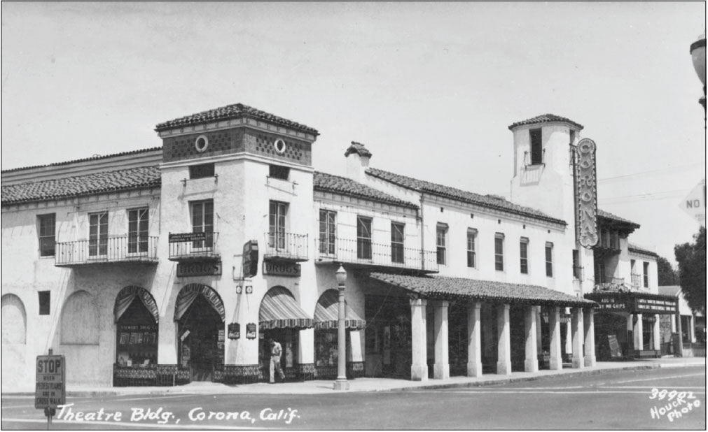
View from the southwest from the south side of Sixth Street at Ramona Avenue
Corona Theater (added 1991 - Building - #90002127)
Also known as the Landmark Building
Location: Landmark Building, 517 Ramona, Storefront occupancies facing
Sixth Street, 201 East Sixth Street, Theater: 211 East Sixth Street, Corona.
Historic Significance: Event, Architecture/Engineering
Architect, builder, or engineer: Boller, Carl, Glass, Perle
Architectural Style: Spanish Revival
Area of Significance: Architecture, Social History
Period of Significance: 1929-1964
Owner: Private
Historic Function: Recreation, Culture, Theater
Current (2018) Function: Church
A Nomination to the National Register of Historic Places was submitted in 1990, It was favorably acted upon in 1991 by the California Historical Resources Commission but the owner declined national listing at that time. According to the State Office of Historic Preservation it remains eligible for listing should the owner remove the
objection to listing by sending in a notarized letter requesting removal of the objection..
The Corona Theater was constructed in 1929 in a Spanish Colonial Revival/Italianate style of architecture. The Corona Theater exhibits an extremely rare, and possibly unique, example of an Italianate façade within the 300 or so theaters designed by nationally prominent theater designers Carl and Robert Boller, Carl being the principal
designer of this theater. This beautiful facility, with store fronts sited at 201 E. Sixth Street, tenants over the years included, Bokay Travel, Modern Barber Shop, Pacific Telephone, Southern California Edison, Stewart Drug, Mava Ice Cream, Houck Studio of photography and offices at 517 Ramona Avenue, including the local Masonic temple, offices of Attorney A. E. Ganahl, physician James Farrage, K. P. Key Insurance, California Fruit Growers Exchange, Queen Colony Fruit Exchange, Jameson Company citrus growers and even the offices of the Corona Norco Teachers Association, and many others, The theater at 211 E. Sixth Street, was Corona’s first theater to show movies with sound and screened movies from 1929 to 1982. The Sixth Street portico was removed and the original rectangular marquee was modified in 1956 when Sixth Street.
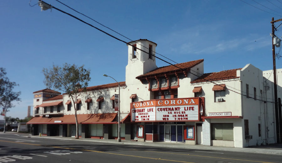
A view of the Corona Theater from the southeast in 2013
Thomas Jefferson Elementary School 1927-present
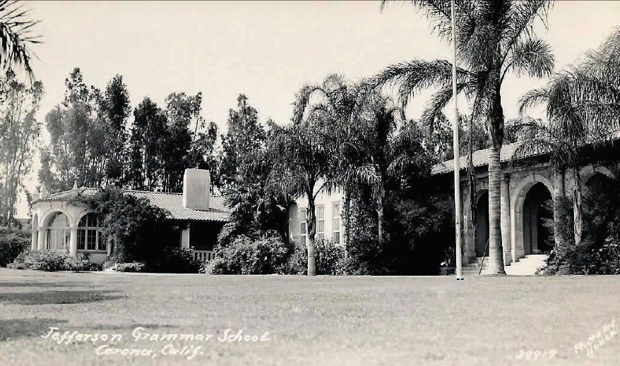
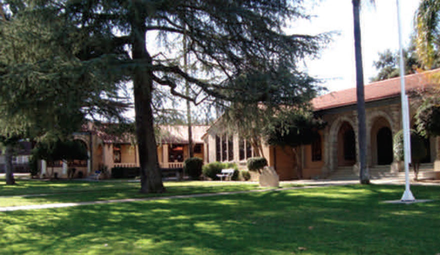
Thomas Jefferson Elementary School (added 2017 - Building - #100001663)
Location: 1040 South Vicentia Avenue, Corona, CA
Historic Significance: Architecture/Engineering
Architect, builder, or engineer: 1927-W. Horace Austin, 1931-G.Stanley Wilson.
Architectural Style: Spanish Mission/Colonial Revival
Area of Significance: Architecture, Social History
Period of Significance: 1927-1931
Owner: Local Government, School District
Historic Function: Social Historic Sub-function: Education/School
Current Function: Social Current Sub-function: Education/School
Thomas Jefferson Elementary School, located at 1040 Vicentia Avenue, sits on the southwest corner of Vicentia Avenue at Tenth Street.. It was built as a one story structure in the Spanish Colonial/ Mission Revival style and constructed in 1927 by noted architect W. Horace Austin. The south wing, with a complimentary design in the same architectural style, was added in 1931 and designed by famed architect G. Stanley Wilson Although designed as the school’s auditorium, including a raised stage, it is now the school library,
A reinforced concrete foundation supports the building. The stacked concrete base of the main building forms a shallow pier. There is a basement beneath the 1931 library addition. The stairwell leading to the basement has pipe railing, which was used extensively in the Depression era. The 1931 structure is primarily painted concrete with wrought iron elements.
The tiled, low-pitch, cross-gabled roof reflects the Spanish style design. The front entry on the library wing also features a wrought iron gate with the initials “TJ” for Thomas Jefferson, for whom the school was named. On the Tenth Street side, an exposed aggregate landing leads to the side entryway framed by two decorative concrete medallions painted blue.
The south wing, added in 1931, is separated from the main building by an open walkway with overhead cover and was originally built as an auditorium/multi-purpose room featuring a small, front-facing (east) rotunda with a rounded hip roof before the gabled rear rectangular mass. The façade of the rotunda is segmented into eight bays by round precast concrete columns supporting arched openings with carved relief detail, all topped by a thick cornice. The rounded columns pierce the roof to emerge as squared, pointed pinnacles. This mock pergola supports a moderate eave overhang and frames eight sets of three wood-framed, six-lite steel casement windows with red tile sills and arched dividedlight casement transoms. Remaining fenestration (window description) consists mostly of paired single casement windows with red tile sills separated by miniature pilasters. An end wall chimney is found on the north wall near the front of the wing, and a small,
arched breezeway near the rear. The pergola that runs the length of the north elevation with arched openings on each end is accessed by three concrete steps on the east and secured with double wrought iron gates on the east and towards the rear along the north elevation, and a gate also faces south within the former breezeway; all gates bear the initials, “T.J.” for Thomas Jefferson, for whom the school was named.
ANDREW
CARNEGIE
LIBRARY
Corona Sites Listed on the State Register of Historic Places only
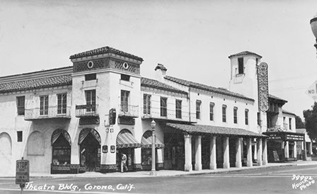
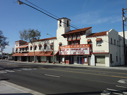
Corona Theater - Landmark Building (Added 1991 – Building - #90002127)
Location: 201-211 East Sixth Street, 517 South Ramona Avenue
Historic Significance:. Architecture - Engineering, Event
First movie theater with sound in Corona
Architect, builder, or engineer: Boller, Carl , Civil Engineer, Glass, Perle, Superintendent
Area of Significance: Entertainment - Recreation, Architecture
Period of Significance: 1929 – 1949
Significant dates: 1929 - 1982 Movie theater, sound movies
Owner: Private
Historic Function: Commerce/Trade, Recreation and Culture
Historic sub-function: Business, Theater
Current Function: Commerce, Trade, Religion
Current sub-function: Business, Religious Structure
The Spanish Revival style Corona Theater, located on the southeast corner of Sixth Street and Ramona Avenue (also known as the Landmark Building when accessed from its 517 South Ramona Avenue address, was designed by famed Southern California architect Carl Boller and dedicated on August 29, 1929. Local contractor Perle Glass supervised the construction. Various celebrities including Al Jolson, Laurel and Hardy, Irving Berlin, Clara Bow, Hoot Gibson, and Delores Del Rio, attended its grand opening ceremonies along with movie industry personalities Sid Grauman, Joseph Schenk and Harry Richman. Its L-shaped design features a two-story elevation in front and three stories in the rear, with separate segments of varying heights topped by individual gable roofs and interspersed with hipped roof towers. The building was constructed of brick, with stucco on its front elevation. Some remodeling has been done to the exterior (the portico over the Sixth Street sidewalk and the modifications to the marquee are the most obvious), but significant details remain. Over the years, the building has had various uses, including commercial office space, a Masonic Lodge meeting hall and as a religious sanctuary. The building Is the only pre-Depression Era theater remaining in Corona, and has been determined eligible for the National Register but was added only to the State of California Department of Parks and Recreation (State Historic Preservation Office) Historic Resources Inventory because the owner declined listing on the National Register of Historic Places
Corona Sites Listed on the County listing of Historic Resources
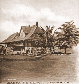
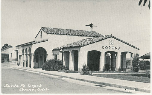
Corona RR Depot building, located at 150 Deport Drive, was surveyed on February 12, 1983 and is registered with the State of California (No. 33-1720-2-144). The Corona Depot is listed on the City of Corona Historic Resources Inventory, and the Riverside County Historical Resources Inventory. It is listed as eligible for inclusion in a Riverside County identified historic district located in Corona generally bordered by Railroad Avenue on the north, Lincoln Avenue on the west, Chase Drive on the south and Rimpau Avenue on the east by the State of California Department of Parks and Recreation State Historic Preservation Office.
The Corona Depot is located along the south side of the railroad tracks immediately west of North Main Street. It is one of four such depots along the original Santa Fe Railroad Santa Ana Canyon line, including depots in Claremont, Monrovia, and Upland (then North Ontario). The four depots were designed in the Spanish Colonial/Mission Revival style by architect H. L. Gilman and constructed in 1937 (Corona’s 50 year anniversary) by Hoagland Engineers and Construction Company of Long Beach. The four depots were built as “combination depots” that included a passenger waiting room, an office, and a freight facility for citrus fruit shipment. The depots were owned and operated by the Santa Fe Railway Company. Both the present Corona and Upland depots replaced older Victorian style structures structures of essentially identical design built in 1887-1888 on the same locations.
California State Historic Markers located in the Corona/ Temescal Valley area
NO. 185 SERRANO BOULDER - As early as 1818, Don Leandro Serrano had cattle, sheep, cultivated land, and orchards in Temescal Valley. The boulder placed by residents of Temescal Valley marks the site of the first house in Riverside County, erected by Leandro Serrano about May 1824.
Location: From I-15, take Old Temescal Canyon Rd S 0.4 mi to Lawson Rd, then go W 0.2 mi to dirt rd, then S 0.1 mi to site, 9 mi S of Corona
NO. 186 SERRANO TANNING VATS - Nearby, two vats were built in 1819 by the Luiseño Indians under the direction of Leandro Serrano, first non-Indian settler in what is now Riverside County. The vats were used in making leather from cow hides. In 1981 the vats were restored and placed here by the Billy Holcomb Chapter of E Clampus Vitus.
Location: NW corner of I-15 and Old Temescal Rd, 8 mi SE of Corona
NO. 187 CARVED ROCK - The petroglyphs were carved by the Luiseño Indians, their meaning is said to be: 'A chief died here. These are his plumes, his portrait, his sign, and the animals sacred to him.' The Luiseño Indians who lived in Temescal Valley belonged to the Shoshoean linguistic group. The rock has been damaged by vandals.
Location: In canyon, 0.4 mi N of I-15 (P.M. 32.5), 8 mi S of Corona
NO. 188 BUTTERFIELD STAGE STATION - Site of Butterfield Stage Station where mail was delivered and horses changed. The first stage carrying overland mail left Tipton, Missouri on September 15, 1858 and, passing through Temescal, arrived in Los Angeles October 7, 1858. Due to area development, this marker, which was located near the water course of the Temescal Creek, no longer exists. A substitute marker was placed on a large rock in the pedestrian plaza at the north end of the Dos Lagos water feature and bridge. (approximately 1000 yards north and slightly west of the original location) by Dos Lagos developer Ali Sahabi.
Location: 20730 Temescal Canyon Rd, 7 mi S of Corona (original)
North of 2785 Lakeshore Drive (Wood Ranch BBQ and west of Temescal
Canyon Road (replacement)
NO. 190 PAINTED ROCK - In tribute to the earliest record of any people in this region, the Santa Fe Railway has preserved this rock with its ancient pictograph, and the Committee of the Corona Women's Improvement Club has placed this tablet.
Location: From Temescal Canyon Rd, go 0.1 mi E on Dawson Canyon Rd, then go 0.1 mi NE on Gravel Pit Rd, then 0.2 mi S along railroad track berm, site is 50 ft W of berm, 7 mi S of Corona
NO. 224 RUINS OF THIRD SERRANO ADOBE - Don Leandro Serrano set out orchards and vineyards and cultivated some of the fertile lands of the Temescal Valley. In the 1840s he built his third adobe, which the Serrano family occupied until 1898, on the well-traveled road between San Diego and Los Angeles.
Location: NE corner of I-15 and Old Temescal Road, 8 mi SE of Corona
NO. 638 OLD TEMESCAL ROAD - This route was used by Luiseño and Gabrieleno Indians, whose villages were nearby. Leandro Serrano established a home here in 1820. Jackson and Warner traveled the road in 1831, and Frémont in 1848. It was the southern emigrant road for gold seekers from 1849 to 1851, the Overland Mail route from 1858 to 1861, and a military road between Los Angeles and San Diego from 1861 to 1865. In the early 2000s, the original bronze marker removed by vandals. In 2013 it was replaced by a similar sized granite marker, on the original river rock monument, provided by Glen Ivy Hot Springs.
Location: On Old Hwy 71, 0.9 mi S of I-15 and Temescal Canyon Rd interchange, 11 mi S of Corona
NO. 738 CORONA FOUNDERS MONUMENT - In tribute to Corona’s five founders: Robert B. Taylor, A. S. Garretson, George L. Joy, Samuel Merrill and Adolph Rimpau, the 20-30 Club of Corona, in 1936, placed a rock with a bronze plaque attached to it, in Corona’s City Park...It is usually referred to as “Founders Rock.
Location: Corona City Park, 930 East Sixth Street, between Grand Boulevard and Rimpau Street on the north side of Sixth Street.
